East Trail - Mt. Pisgah - Westmore, VT
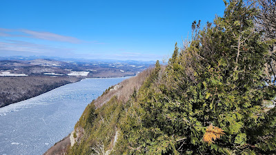
East Trail - Mt. Pisgah, 4.5 miles out & back, 1141 elevation gain Wow, it's been 9 years since I last posted on this blog! A lot has changed, I post all my hikes to Facebook https://www.facebook.com/snowdoghikes . I relocated to the Northeast Kingdom of Vermont, I talk to a GoPro while hiking, and I became section president of a hiking club, the Northeast Kingdom Section of the Green Mountain Club ; and often lead hikes to show others this area of the state. (Click on any photo to enlarge) The Pisgah East Trail , (also known by some as the Long Pond Trail on Pisgah, which can easily be confused with the nearby Long Pond Trail on Bald) is a relatively easy hike on a not very well marked forest road, but to get to the summit you need to take a short steep section on the North Trail, which makes this a much more challenging hike. On this day I was able to wear micro-spikes and walk on top of the snow. At the first field opening be sure to turn right and continue following the