East Trail - Mt. Pisgah, 4.5 miles out & back, 1141 elevation gain
Wow, it's been 9 years since I last posted on this blog! A lot has changed, I post all my hikes to Facebook https://www.facebook.com/snowdoghikes. I relocated to the Northeast Kingdom of Vermont, I talk to a GoPro while hiking, and I became section president of a hiking club, the Northeast Kingdom Section of the Green Mountain Club; and often lead hikes to show others this area of the state. (Click on any photo to enlarge)
The Pisgah East Trail, (also known by some as the Long Pond Trail on Pisgah, which can easily be confused with the nearby Long Pond Trail on Bald) is a relatively easy hike on a not very well marked forest road, but to get to the summit you need to take a short steep section on the North Trail, which makes this a much more challenging hike. On this day I was able to wear micro-spikes and walk on top of the snow.
At the first field opening be sure to turn right and continue following the forest road to the next opening. There is a sign in that field that points right again.
Here you will continue following the forest road to a Y intersection where you will take a left to another sign which leads away from the forest road on a trail.
This short section (0.3 miles) leads to the North Trail. From here is gets aggressively steeper and on icy days we have turned back.
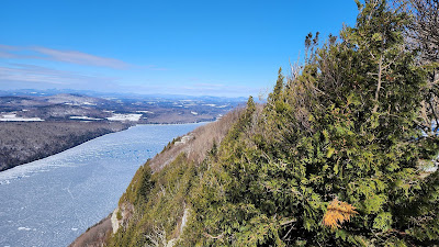
Within a short distance (maybe 0.2 miles) you are back to a gradual climb to the summit. There are several spur trails to viewpoints. I usually skip the North Viewpoint and go to the next. Views of Lake Willoughby below.
Continuing south we head to the summit
The summit
When I hike I carry lots of safety gear, extra layers, wilderness first aid kit, blanket, emergency beacon, whistle, and stove. One of my favorite things to do on a winter hike is cook some food once I reach the summit. On this day, because of the wind, and temperature (18°F), I hiked back to the East Trail before cooking. I really like this company
Packit Gourmet.
Wasn't long before I was back on the trail again heading to the trailhead.


Comments
Post a Comment