South Trail - Mt Pisgah - Westmore, VT
This South Trail is 1.9 miles, with 1,462 feet of elevation gain, a gradual climb to the summit of Mt. Pisgah. The trail is mostly easy, though there are a few intermediate spots along the way (Ha! Right!). It's a popular hike with lots of Canadian hikers; a good place to practice your French. The views are a little farther to the West and North viewpoints. The lake is visible through the trees for most of the way.
The Trailhead.
It starts off flat and you soon come to a boardwalk.
I caught a glimpse of a King Fisher here, but was unable to get a photo.
Lots of beautiful stairs along the way.
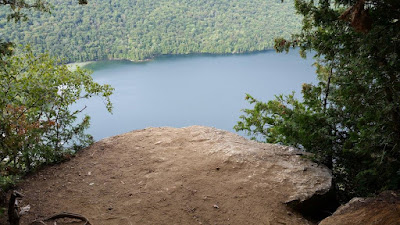
The first viewpoint looked a little precarious to me. This is as close as I would get.
There was also large boulders all along the way. My guess it leftovers from the glacier (Erractics).
Finally, after climbing some open rocks I arrive at the South View.
The summit is in the trees with no view. This sign was stolen and we replaced it in 2023.
Breathtaking North View.
Map & Directions: https://www.trailfinder.info/trails/trail/willoughby-state-forest-mount-pisgah


Comments
Post a Comment